Thursday, April 28, 2011

Firescald to Big Bald

If you play with fire, you're gonna get burned.

While I didn't get burned, I did get scalded, a scolding from Mother Nature. Looking back I wish the name "Firescald" alone would have reminded me of that childhood aphorism. But then again, when you're hiking the AT, there aren't many decisions that you have to make. Sure, food is a big one; so is where you'll find water and make camp. Other than that, it's just a rather mindless exercise of following the blazes. Occasionally there won't be a blaze where you need one and you may not know at first which way to go. Other times you may find yourself perplexed at a double blaze, an indication that the trail does something that you should pay attention to: the start of a switchback, an intersection with another trail, or similar situation where if you're not observant you could easily find yourself walking off-trail.

So yes, there are decisions to be made, but Firescald Knob forced a new choice into my path: a choice between two viable options.

I took a moment to look at the sign, then looked up at the sky. There was plenty of gray, but that had been true all day. There was also plenty of wind, also present since morning. Given how normal the overcast, blustery weather had been I didn't give the sign much thought. Besides, why wouldn't I remain on the "true" AT path?

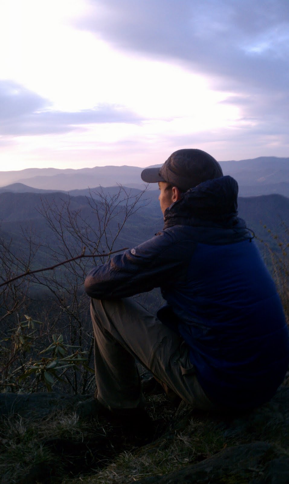
I went for the exposed ridge and was excited because a local told me that Firescald provided some of the best views from the trail thus far. As the trail wound up the ridge, the trees got smaller. Then the trees gave way to only rhododendron and mountain laurel, and before long even they became stunted in their growth due to the harsh, exposed ridge environment. Now being the tallest life form on the knob, I got my view and I didn't like what I saw.

The spine of Firescald stood tall, over 4500 feet high, towering over the valley to the west. As the westerly wind hit the mountainside it was hurled upward and its warm air collided with the cool, ridgeline atmosphere. The result: localized thunderhead clouds taking shape and billowing upward just to my left. Knowing that lightning can lead the edge of a storm by as many as ten miles, I now felt exposed on the "exposed ridge" trail. An impending sense of doom intensified as the first peal of thunder ripped across the sky. I suddenly felt taller than I ever had before.

So I did what anyone might do: snapped a picture to try and capture the moment, and then hightailed it north to lower elevations. The next half mile of scrambling across ridgeline rocks seemed like an eternity. I exhaled a welcome sigh of relief once I felt safe(er) amidst trees once again taller than me.

Later that evening I stopped at a shelter to enjoy a warm dinner: mac and cheese with tuna and freeze-dried peas, corn, and red bell pepper. Delicious. It was only 6:30 when I finished eating and the next shelter was six miles away with downhill terrain between. I could make it in two hours, so I pressed on. Soon after the sun dipped below the horizon, I crested a hill to find myself in a strange location. The ground was covered in healthy, green grass amidst a stand of pine that was mostly standing dead. I then passed multiple piles of bear scat adorning the trail, only to reach a headstone of a thirteen year-old girl who had lived and died in the late 1800's. The gravesite was decorated in fake flowers that looked strangely neon in the dusk sky. The whole stage left me with an eerie sensation, an acute visceral reaction that I wanted to leave the bears, the dead pine, and the fluorescing grave behind ... and quickly. It's a good thing it was dusk or I would have also noticed the perfectly preserved bear tracks in the nearby mud.

Two days later I found myself hiking up Big Bald. The morning air was crisp and the winds were high, sustained at 20 mph with gusts at 40 or more. As I crested Big Bald I hiked up and into the low-lying clouds. The suspended mist whisked by me, resembling the dust tossed up from a dry dirt road, recently disturbed by the tires of an old pickup. As I neared the top the wind grew in force, making it difficult for me to stay on the trail; each heavy gust left me as helpless as a piece of tumbleweed, tossed about like a rag doll. From the summit the trail dipped into a saddle and then back up the neighboring Little Bald. Venturing into the gap I marveled at the power of the wind. At eye level clouds were tearing in from the east of the bald as well as from the west, ripping past each other across the trail ahead of me. Just overhead there was a third wind pattern slinging clouds northward in the direction of my travel. I have never seen wind patterns with three different paths swirling in the same location, made visible by the misty clouds they took with them. It was truly a sight to behold.

It just goes show that mountain weather is an interesting, powerful and unpredictable force of nature.

Saturday, April 23, 2011

It's all Downhill from Here

Before I write about my four days and three nights in The Great Smoky Mountains National Park, I need to get something off my chest: I didn't see a bear. For all the hype about two bears for every square mile and this season's higher numbers of bear cubs, I expected otherwise, just shy of being welcomed into the park by Smokey the Bear himself. Instead, I saw one pile of bear scat to tease my imagination, and my bear radar never even blipped once.

That's not to say there weren't good memories from the Smokies, but I'm not sure I ever did make a full recovery from bearing my initial bear-less disappointment. There were good memories, to be sure. There were also those that bordered on the bizarre, and others still that I hope to quickly forget.

Day 0

Before even crossing Fontana Dam into the park, my attention was quickly pulled from studying the spectacular amount of cement that is required to hold back a lake with over 10,000 acres of surface area and 238 miles of shoreline. My gaze went from the spectacular to a spectacle, from the dammed lake to a sea of yellow, as fifty-five Mustangs displaying four shades of bright yellow paint thundered into the parking lot.

I went from not seeing one car over the past three days to seeing a swarm of American muscle that you couldn't help but be mesmerized by. And after having the urge to pee, I couldn't wait to get into the park and run away from the Yellow Mustang Registry.

Day 1

I entered the Smokies after a night at The Hike Inn, weathering the deadly tornadoes that swirled on either side of Fontana. The initial uphill hike inside the park led me up to a rickety old firetower.
The angle iron was rusty, some of the wooden steps were rotting, missing bolts, or both, and a wind advisory was still out from last night's storms. The higher I climbed the stronger the wind became and the more the tower shook and swayed. Quite the adventure with quite the view.

From there I went deeper into the heart of the Smokies, with my left foot in Tennessee and my right in North Carolina. I soon found myself where the Spring Beauty could be mistaken for a light dusting of snow resting at the feet of a grove of Buckeye trees. Once I reached the first shelter I took a half-hour break while the temperature dropped a degree a minute, settling near forty degrees. The once snow-like Spring Beauty shut their petals and bowed their heads as they endured the cold; I shut my jacket and bowed my head as I hiked on to stay warm.

Day 2

The next morning I woke up to a quarter-inch of frost, windblown off the sides of stems and limbs. I had slept through the snow and ice that fell overnight, glad to still have my warm sleeping bag. Once I started hiking the wind blew the frost off the branches, the small crystals falling as snow against a cloudless blue sky, and the large flakes of ice falling to the trail as wood chips on a playground. As I hiked up Rocky Top the sun beamed down, glistening off the ice frozen to the surrounding grass. I could barely see a thing, and in a strange way it felt as though I were climbing Mt. Sinai, only at the top there was stone but no tablets.

The other side of Rocky Top gave way to more Spring Beauty with Trout Lily interspersed. However, the serenity of that view was quickly besieged by a group of singing hikers. It was obnoxious, really, as I had no interested in hearing Casey Kasem's Top 40 while on the trail. Unfortunately, the off-key a cappella gang followed me all the way to Clingman's Dome, the highest point on the AT, and farther still to the Mt. Collins Shelter where I had the duty to try and fall asleep to their bellowing. I planned an early start to the morning, and I wished more than ever that I would see my first bear that night.

Day 3

As planned, I woke up and hit the trail early. The morning began entering what seemed like Mirkwood forest. The thick pine blocked out the sun, leaving the forest floor dark and damp, an environment where even a slightly creative mind could imagine evil lurking in the shadows, perhaps even the Giant Spiders that inhabited Mirkwood itself. Thick moss lay covering the ground, dripping from fallen logs, and creeping up unsuspecting trees, adding an eerie green hue to the undergrowth. The trail was muddy and narrow, the going as treacherous as my imagination would allow.

From there the trail emerged once again into swaths of Spring Beauty. Only this time the grove of Buckeyes was replaced by a stand of pines, many of which had long since seen their youth. The eldest of the pine stood as only skeletons of their former selves: stripped of their bark, sun-bleached, and ashen-gray, they still stood proud, preserving the memory of their former prowess, though they no longer clung to life. I wondered if this was part of the natural lifecycle of the pine, a hazard of rooting on a ridge in the Smokies, or a plight brought about by an invasive species of some kind.

Day 4

My last day in the park was a collision of worlds where the Smokies were visited by Thor and his mountain-leveling hammer. Long stretches of trail saw large trees level with the ground, as if Thor got carried away in a game of "king of the mountain" and brazenly swung his hammer, swatting down any tree in his path. Some of these trees rested precariously against others as they leaned over the trail. In the wind they would creak and moan as bark ground against bark, daring any hiker to pass underneath. I warily trekked on, and soon found the northern boundary of the park.

With the Smokies behind me, three things have changed. First, I now hope Shenandoah will provide what the Smokies did not: the bear sighting I desire. Second, I now say that I am hiking to Katahdin and not just hoping to. Sure, hope is still an important part of the journey, but I have a large measure of confidence now too. Third, after cresting Clingman's Dome, the highest point along the Appalachian Trail, I can now say that, "It's all downhill from here."

Friday, April 22, 2011

Who Needs a Map and a Compass?

Navigation on the Appalachian Trail is an interesting discipline. On the one hand, it's as basic as following the white blazes that are painted on trees, rocks, fence posts, and signs, marking the way north (or south). It's like following Hansel and Gretel's trail of white pebbles. Simple, functional, and you don't even need a "White Blazes for Dummies" handbook. It just makes sense.

The white blazes make map and compass work entirely peripheral to the hiking experience, to the point where the map and compass just add unnecessary weight to an already burdened pack. In this way a data book, with mileages between water sources, shelters, peaks, roads, towns, etc., is much more useful. This is the resource that I carry, and it's worth its weight in gold.

If you dig a little deeper, the navigation question becomes more complicated. For example, let's take a look at the question, "Which way is north?" You could be talking about "AT north," which, if you're hiking from Georgia to Maine, is whatever direction your facing while hiking. Data books rely heavily on AT north, referencing objects as west or east of the trail, when really they mean left or right.

You could also be talking about true north. As you stand on the trail, this would be the direction you would have to face in order to be looking at the North Pole. If you've ever used a road atlas, these maps are oriented with the top of the map pointed toward true north. Again, pretty simple.

Finally, you could be talking about magnetic north. If you did take the extra weight of a compass during your AT hike, this is the direction the compass needle would point. But isn't that the same as true north? It depends on where you are, and on the Appalachian Trail that is never true because magnetic declination comes into play. Declination is the angle, measured in degrees, between magnetic north and true north. In general for 2011, the Mississippi river draws a north-south line across the US where magnetic and true north are close to the same. As you head east toward the Appalachians, the compass needle is "pulled" back west toward the Mississippi; the further east you go, the further the needle is pulled. At the southern end of the trail the compass needle is pulled counter-clockwise about 5 degrees; at the north end, declination grows to 15 degrees or more. So, while on the Appalachian Trail, to calculate true north you have to "add back" the declination to the compass reading to get true north. In other words, you are theoretically moving the compass needle clockwise the amount that it has been pulled counter-clockwise (or west) by declination. Make sense? If you're still confused, believe me, you're not the only one -- and I haven't even mentioned yet what happens when you head west of the Mississippi instead of east toward the AT, or how declination changes over time, but that's for another post.

All of that to say, on the AT I've found that it's more interesting to know where you're headed by sight, not by any of the three meanings of north. Yes, sighting the white blazes is part of what I mean, but there's also another meaning that is a bit more subtle and requires some practice. When I'm standing on a peak, I first enjoy the view. Then I'll look in the general direction of "AT north" and try and spot the next prominent mountaintop. Nine times out of ten, this is where I'm headed next. What if that next bald is some distance away? Usually, I'll just use line of sight to connect the summit I'm on to the one in the distance by a ridge line or gap that connects them; and if not a ridge, I'll visually connect the knobs that stand in between like a simple game of connect the dots. It's amazing how with a little experience, this method of navigation is fairly reliable, made possible by the fact that the AT loves to visit the vistas and other high points of the mountains along its course.

So how would you navigate the AT? Visual anticipation? A map and compass? Just a data book? Nothing at all? You'll find all of these types of hikers if you spend enough time on the trail.

Sunday, April 17, 2011

Somewhere South of Solitude

Before I ever stepped foot on the AT, I anticipated being mostly alone. Getting to the top of Springer I found myself surprised as I stood there with at least twenty other people -- some fellow thru-hikers, some section hikers, and some tourists. Hiking off Springer there were quite a few people who passed me going the other way. Not long after, I crossed a parking lot with a flurry of activity. Then at Stover Creek Shelter, where I spent my first night, I ate dinner and turned in for the night alongside about 20-25 other people, some in the shelter, some in their tents.

The next few days were similar. I would often run into people while hiking, commonly while stopping for breaks. Then, when stopping for the night, I would find myself with many others at a shelter location. This all made sense, though. The first weekend in April is the most common time to start, and the shelters are located near water and often have a privy. Even so, there were times when I felt like a lemming just following the masses, and wished for the days when hiker traffic would thin.

Since those early days, patterns have begun to change. The faster hikers have long since disappeared around the next bend, and I have begun to put more distance between myself and slower hikers -- some have a slower pace, some walk fewer miles, and others enjoy more downtime and rest days. The result is that I see fewer people during the day, and when staying at shelters I have fewer neighbors. I am also starting to camp at non-shelter locations more frequently.

Left: "Tent City" beside Blue Ridge Shelter, my fifth night on the trail

Even with the quieter days, I still haven't found much solitude. I don't expect that to change much in the Smokies. There, all hikers are required to stay at shelters, and tourists compete with thru-hikers for beds. However, I do expect it to change north of the Smokies and into Virginia. As I begin walking in "home" country, I expect to have most of each day to myself. I'm looking forward to it, even though I'll miss sharing the trail with some of the other hikers I have met who I now consider friends.

There will, of course, be others who I don't miss at all.

A Botanist's Playground

My grandfather was an avid student and teacher of botany. You could imagine, then, his delight had he been able to hike the AT. You can also then understand the sense of obligation that I have as I walk -- a burden to learn and know the plants that I am surrounded by.

It's not just because of my grandfather, though. Just like anyone traveling to a new place, it makes good sense to learn about your new surroundings. I am a guest of the trail and the woods that it winds through, a sojourner moving from one white blaze to the next. Because of that, I desire to know the place where I find myself. Simply put, it's a part of being a good guest and appreciating all that the host has to offer.

If I were a better student of my grandfather, there wouldn't be quite so much to learn. Of course, had I been a better student of my mom, I would be familiar with the birds as well. And, if I had been a better student of my dad, I would have photo-documented all that I have seen thus far. The fact remains that I stand here with much to learn and very few photos.

That being said, I've made progress. Remember that mystery flower from a few posts ago? It is known as Bloodroot. If you break its leaf, you'll find a fluorescent orange sap oozing from the tear. And if the color weren't enough to grab your attention, this sap is known for its plaque fighting abilities ... it is said to ward off insects ... and, when used as a dye, it becomes blood red, a fact that becomes particularly useful in case you are planning on decorating Easter eggs while in the wilderness. Bloodroot is by far my new favorite flower in the backcountry. Really, what more could you ask of one plant?

There are more cool plants in the Appalachian hills. The Rattlesnake Orchid makes the list, with its leaves that resemble rattlesnake skin. In fact, according to the "doctrine of similarity," this plant has historically been used as a treatment for rattlesnake bites. I'd wager a guess that the historical success rate has been less than desired. Then again, if I found myself bit by a rattler and sitting next to one of these orchids, I'd use it. It's worth a try, right?

I've also seen Fire Pink, a red flower with petals that are forked at the tip. At first blush I thought, "Who in his right mind would call this flower pink anything? After all it's red and looks like a snake's tongue." Little did I know, "pink" refers to that very shape, as each of the five petals is pinked, or notched, at the tip. Common sense prevails yet again.

The Mayapples have been pitching their umbrellas, the fiddlehead ferns are opening, and I've seen just about every color violet you can think of: dark violet, pale violet, pink, indigo, and yellow. Beyond that there are all the combinations: dark violet with pale edges, white with purple streaks, purple with white highlights ... and the possibilities are too many to name.

In addition, I've noticed Dwarf Purple Iris, Perfoliate Bellwort, Daisy Fleabane, Squawroot, Trout-lily, Wild Geranium, Spring-beauty, Wood-sorrel, and Toothwort. I hope to be able to spot at least one Dutchman's Breeches before leaving the Smokies, in honor of my friends back at Calvin.

And here's where you come in. There remains one flower that I've spotted and have yet to identify given the resources at my disposal. Can you name the flower in the picture below?

Saturday, April 16, 2011

Jacob's Ladder

They lied. The 8 mile slog heading north out of the NOC is not the hardest section of trail south of the Whites. In my book, Jacob's Ladder wins. And in case you begin to think that all I write about is climbing hills, it's because that's what I do. Right now, hills are my life. If I'm not going up them, I'm headed down; if I'm not going down, I'm upward bound; and if I'm doing neither, I'm sleeping, most likely on some kind of slope, however slight.

From the name "Jacob's Ladder" you might immediately think of the activity found at a ropes course: a giant swinging ladder made out of 4x4s hung from ropes, spaced about 4 feet apart. I'm here to tell you that this section of trail is not like that. The mountain doesn't sway beneath you, and you don't have to awkwardly swing your legs up over you head. Other than that, you've got the right idea.

It's as if The Old Man of the Mountain woke up one day, drank too much bitter coffee, and then mashed a giant slinky into the side of the steepest mountain he could find, carving out a winding path. This, of course, was followed immediately by the brilliant idea to run a national scenic trail along the slinky scar.

Jacob's Ladder is much shorter than the NOC climb at only half a mile. But what it lacks in length it makes up in slope. Over that half mile you climb just shy of 600 feet. No big deal right? Well, if you think I'm making a mountain out of a mole hill, I challenge you to make a scale model in a neighborhood sandbox, complete with a Lego action figure of your choice. That visual should help you understand how this ladder is much more than a mole's hill. In fact, there was a near accident as a woman heading south almost didn't get stopped in time before running into me. Yikes! You can add another Lego figure for that if you like.

Standing at the top, thankful to have avoided a head-on collision (I would have lost), I was happy to have reached my goal: climb Jacob's Ladder without stopping. Only this time I had no sunset reward. Instead, I got a grasshopper round of applause, which is arguably even cooler. Past Jacob's Ladder there was a section where swarms of tiny grasshoppers lined the trail. As I walked they would hop out of my way, landing in the dried, brown leaves alongside the trail. Each grasshopper that bombarded a leaf made a clapping sound, multiplied by the dozens. Sure, it wasn't a standing ovation, but it worked for me.

During my stay at The Hike Inn the next day, my suspicions were confirmed by Jeff, who has been lodging and talking to hikers for the past nineteen years. According to him, the AT south of Fontana is some of the roughest of the whole trail. In fact, from Springer Mountain about half of the aspiring thru-hikers quit by Neels Gap. By Fontana, two-thirds have thrown in their packs. However, once you cross the Fontana dam, it's a new trail -- not easy, but not what it has been.

I'm thankful to find myself in the small group of thru-hikers who venture into the Smokies, and looking forward to gentler trails ahead. I hope to be among the quarter of those who start who also finish.

Wednesday, April 13, 2011

I think I can, I think I can

The Nantahala Outdoor Center (NOC) apparently doesn't want northbound hikers to leave. After descending the 2,500 feet into the valley, I stopped to sun my clothes on a kayak, mail a package, and eat lunch. It was a relaxing morning, especially after the past three days.

I had strung together two 16 mile days chased by an 18 miler. Why? The first two were because of peer pressure. The last because of the weather. You see, Monday night, sleeping at Siler Bald shelter, I only thought I was safe from the incoming weather, tucked away under the shelter's tin roof. In fact when the rain first started falling, the ding of the droplets off the tin reminded me of home. But once the winds nearly ripped the tin clean off (or so it sounded like), home disappeared quickly amidst racket. More lightning, thunder and wind. Only this time the hail was replaced by buckets of rain. The shelter might as well been situated beneath the giant tipping bucket of water that you'd find at a Great Wolf Lodge. And when you add lots of wind with lots of rain, things get wet, especially in a three-wall shelter.

So I woke up with vague memories of my face being misted throughout the night. The foot box of my sleeping bag was damp. My boots were water logged. And my pack, hanging from a line to keep the mice out, but too close to the edge of the roof, was soaked, along with it's contents. In case you're wondering, pack covers can only do so much, and that is very little in a windy downpour.

So I started Tuesday cold, wet and tired after the two 16 mile days. I was hoping within a hour or two the foggy clouds would clear, being burned off by the sun. Instead the day brought more cold (it hovered in the low 50's), more wind (15-20 mph), and more rain. Everything was wet to start the day and everything just got more wet. So I hiked, and hiked, and hiked some more, stopping in shelters along the way. I hiked not because I wanted to, but because I wanted to stay warm. At the second shelter I even cooked up some soup to help fight off the hypothermia. And then I hiked some more, as the trail began to look more like a stream. When I finally stopped hiking, the rain abated as well. And at 8pm, the sun peeked out for ten wonderful minutes.

So, I sunned my clothes on a kayak once I got to the NOC. And after drying out my gear and filling my belly I was ready for a nap, not more walking. And then I looked at the map. The task that awaited was to climb 3,339 feet over 7.9 miles. It's true, the NOC doesn't want you to leave.

But I left. The beginning wasn't bad: not too steep, and my IT band that I had been nursing the past few days wasn't acting up. There were also flowers in bloom that were just leaves south of the NOC. Life was good.

But as the miles wore on, things got steeper. Straight trails became switchbacks, only to straighten when things got even steeper.

A steep section of trail

Dirt trail became rocky. Smooth trail found the spines of old ridges. Blueberry bushes made me wish they were in season so I could sit down and pick the best berries. And the three gaps that were crossed seemed to only provide enough time to flush the built-up lactic acid and allow a full stride to begin to stretch out the legs.

A view of the NOC from "The Jump-up" at 3,789 feet, still over 1,200 feet shy of the bald

Now if you've read some of my other posts, you would know that I've mentioned climbs before. And if you've read between the lines, you would have heard me softly complaining. But this climb was different. It is slated as the hardest climb south of the White Mountains, and I was tired when I got to the top 4 hours later.

That said, all the work had a handsome reward. As I passed by the Sassafras Gap Shelter for Cheoah Bald to camp, this was my reward:

Sunset on Cheoah Bald

This was one of the most beautiful sunsets I have seen, probably because it was well earned. And now I can't wait for sunrise tomorrow.

Sunday, April 10, 2011

Sweet Caroline

Yesterday I crossed into North Carolina. One state down, thirteen more to go. Only Georgia didn't go down without a fight.

She left most of my morning's work uphill: about 1200 feet of elevation gain from my start in Dicks Creek Gap, with plenty of peaks and gaps along the way. Then, just shy of the border while climbing Rocky Knob, she thought it fitting to present an afternoon thunderstorm as a parting gift -- and it was as spectacular as it was brief. Caught on a ridge the lightning began to strike, too close for comfort. Hunkered down with trekking poles abandoned, I anxiously waited. Then the hail began to fall: peas and gumballs and mentos. Yet it soon stopped as abruptly as it began, and I pressed on to the border.

North Carolina welcomed us with a spring and an old, twisted tree. This tree often finds its image in hikers' photo albums, and it reminded me of Yggdraisil from the lore of Norse mythology. It's amazing where your mind can wander while wandering along.

So much for good first impressions. The next mile in NC was another climb of nearly 1000 feet, and the AT reared its never-flat head once again.

There were a few other things that were a part of my border crossing. I learned that my night in the Hiawassee Inn just the night before was only a year (or so) removed from sleeping in a meth house. I also spotted my first Buckeye tree, right next to the AT's Yggdraisil. I had heard rumor of them all throughout Georgia, but they evaded me until now. And I also met "Mark Trail," an older hiker who has section-hiked the AT before. He likes to call me "Buckwheat," because "Buckeye" is too nice and not random enough. I'll look forward to sharing stories with him down the road.

There is one more thing I should mention before I sign off. I can now say I thru-hiked Georgia on the Appalachian Trail.

Friday, April 8, 2011

Early Morning Blues

Whether it is a solitary mountain or an entire ridge, there is a reason "blue" is an integral part of Appalachian nomenclature. In order to catch a shuttle into town, I woke up and hit the trail by 6:30 this morning, my earliest morning yet. And as I hiked, I was reminded of why.

Before the sun breaks the edge of the horizon its rays begin to provide a faint glow as they bend around the earth. And as you look across the mountains, the nearby greens and browns fade to blue, and the blue then disappears into the distant morning mist. On clear, mist-less days the blue spreads past the mountains into the valleys below, offering a reminder that there is life beyond the Appalachians. And on cloudy days, you often can't tell where the mountains end and the clouds begin; mountains and clouds, clouds and mountains, they are all one blanket of gray-blue.

Then the sun begins to near the horizon's edge. The gray and blue give way to pink and purple. And as the sun's eye emerges into view, pink and purple give way to yellow, orange and red; and a new day is born.

Each day I am early to rise, I will enjoy my early morning blues.

Thursday, April 7, 2011

Spring is in the Air

It's a lovely time to start a long walk north. Hiking in the crisp morning air is refreshing. And although most of the forest is still sleeping, with long-needle pine, rhododendron, and mountain laurel providing the only splashes of green, there are signs of life.

Today I was greeted on the trail by a blue jay, and his friends have been busy sounding off in the surrounding trees. A monarch was fluttering around camp. And some early-blooming flowers have made their presence known. Violets are scattered everywhere; yellow and purple trilliums are opening; and plenty of low-lying white flowers are fighting for the sun. My eye has particularly been caught by a small white flower on the cusp of blooming. It looks similar to a daisy, and boasts greenish-purple leaves reminding me of miniature versions of those found on a oak tree. I'll have to look them up when I can, or perhaps leave that sleuthing to all of you.

Water is flowing freely as well, supporting all this new life in abundance. Seasonal springs are gushing, and where they emerge from the heart of a mountain small oases of moss, fern, and mountain laurel thrive.

This water in plenty is a tangible reminder of God's provision. And all of the awakening new life is a reminder for me of our hope and new life found in Christ. As Spring begins to arrive in full force, my excitement for the next few weeks on the trail is close behind.

Wednesday, April 6, 2011

The Bear and the Tempest

From the time I was 2 miles into my hike I heard about "the storm." Locals would tell me that, "It's gonna be a big one," and, "You won't want to be tenting in that!" And the storm was still over two days away.

All that next Saturday, Sunday and Monday, the trail gossip was stirring:
"It's going to hit Monday night."
"No, Monday afternoon."
"Stop worrying about it. It's only a 30% chance of rain."
"You'll want to get off the mountain. There's a 80% chance of severe thunderstorms."


And so the rumors flew.


Most of Monday was a gorgeous sunny day peaking in the high 80's. By the late afternoon local thunderheads from the day's humidity were rolling in, but still no sign of "the storm." Still, it was decision time. Standing on top of Blood Mountain looking at spending the night in the AT's oldest shelter--made of stone and plenty drafty--through a storm did not sound appealing. Neither did descending the 1300 feet into Neels Gap.
But the storm wasn't the only factor. We were warned by a Ridge Runner that there was unusual bear activity 5 miles on either side of Neels. Then, hiking up Blood Mountain we stumbled across a campsite with a frantically penned note left behind: "Don't stay here! Bear came just after dark and took down both of our bear bags, hung on opposite sides of the campsite. He is NOT afraid of humans ... yelling ... clapping ... throwing rocks. And he WILL be back!" I don't know about you, but that didn't sound very inviting.


But that wasn't he end of the said bear. Near the summit of Blood Mountain there was a bear line left hanging from a tree with an old food bag still hanging from it, ripped to shreds. Someone didn't hang his bag of food high enough.


And then at Blood Mountain Shelter there was a log book left in the fireplace. There, too, another account of a pesky bear tearing through someone's pack was written.


I thought, "Anyone who ignores multiple storm and bear warnings must not be very wise." And so I pressed on to Neels Gap, thankful for shelter in the Blood Mountain Cabins, but also wondering what kind of adventure I had passed up. I would find out soon enough.


That night I checked the Weather Channel. The forecast was grim. There was a tornado warning, a wind advisory with gusts up to 70mph, hail up to 1.5 inches thick, and severe lightning. I was incredibly thankful not to be stuck in a tent or shelter exposed on a ridge; I also felt for those who weren't so lucky.


The next day I went to resupply at Mountain Crossings, and the store was buzzing. "Did you hear about the bear last night!?" Those were the words that greeted me, and the story was soon filled in.


So it's told, four people were staying in Blood Mountain Shelter. Before the storm hit but after dark, they had the opportunity to watch the bear pick off their food bags one by one. And this wasn't just any bear: it was big--7 feet paw to paw and more than 13 feet tall on its hind legs--and smart. They watched the bear climb the tree, shimmy 10 feet out onto the limb where the food was hung, and pull up the bags of food, one by one, paw over paw, until his snack was complete.


One of the four was fortunate enough to have hung his food on a different tree, and while the bear was busy picking off the others' bags, this hiker got his down and stowed it in his pack which was kept in the shelter. Then, the windows and door were barricaded for the night.


The storm blew in, just as wild as predicted. Amidst the howling wind, pounding rain and rumbling thunder, the four slept in their tents inside the leaky shelter. In the morning they awoke to a new surprise. The pack with food was missing, and one window's barricade dismantled. The bear had struck again, this time coming inside the two-room shelter, just feet from where the others were sleeping.


But they survived. And so did I. Only they have their first AT story to tell.

Monday, April 4, 2011

Thoughts from Springer

Arriving at the top of Springer Mtn after saying goodbye to Tera and hiking 7.5 miles just to get there, it felt strangely enough as though I had "arrived." All the months (and years) of anticipation now had a tangible expression: a small green plaque and the first white blaze painted beside it. And after being the 34th hiker that day to sign the logbook tucked inside an iron box tucked in turn inside a rock, I stood by the plaque -- with images of the Wizard of Oz and Dorothy starting the yellow brick road -- and took my first step. Someday soon I hope to have a second arrival moment, only this time atop Katahdin.

Sunday, April 3, 2011

Saying "Goodbye" is Never Easy

(posted by Tera)
I had the wonderful privilege and honor of driving my husband down to Georgia to the start of the Appalachian Trail. This was a much anticipated trip filled with a whole mixture of feelings, but mostly excitement and dread. It was filled with excitement because it meant that Jon was about to embark upon a journey that he has been dreaming about his whole life. It meant that he would begin a period of self-discipline both physically and spiritually. It meant new adventures and surprises from God. And it meant giving back to an organization (ECHO) that meant so much to his grandpa and of which I am a big fan.

But it was also filled with dread because it meant we would eventually have to say goodbye knowing that the next two months of our lives would be lived in two separate and very different worlds. This was (and is) the hardest part of the whole experience.

I was hoping to be at the start of the trail with him, but some impassible roads made it impossible to get as close to the trail as we had originally planned. Thus Jon had to hike 7.5 from Amicalola Falls State Park where most AT hikers begin their journey. While Jon was registering, the ranger on duty asked if we were from Ohio when Jon revealed his trail name (Buckeye). When we told him that we now live in Michigan, a lovely young couple next to us asked us, “Where in Michigan? We went to Calvin College.” What a small world! To me, it was God’s way of comforting us and reminding us of His sovereignty and perfect timing.

I decided to walk the first half-mile with him carrying his pack. Along the way, we had a Park Ranger take our picture, enjoyed the rhododendrons, marveled at the sunny skies, and agreed that it was the perfect day to start the Appalachian Trail. The whole time, I kept thinking, “I don’t want to turn around, I don’t want to turn around.” Why? Because turning around meant the dreaded “goodbye.” But it came to a point when I realized that a 10 hour drive back to Ohio meant I needed to pass off the pack and turn around. So, through many tears, a parting prayer, one last hug and kiss, we each went our separate ways.

I received a text from Jon when he made it to the start of the trail. He wrote: “I’m sitting on Springer Mountain, enjoying the view. It’s a magical place given all the anticipation. I’ll probably do a few more miles yet today.” So, he is now officially on his journey. I am so proud of him – it takes a lot of courage to make this dream become a reality. To God be the glory now and forevermore.