 In fact, this week held what was arguably the best day on the trail for me. The morning started with a climb up to Horns Pond, tucked at the base of Bigelow Mountain, where I enjoyed overlooking its clear water dotted with lily pads. Off to the west clouds hovered below me in the nearby valley. In a certain manner, I felt as though I was on top of the world as I looked down upon the beauty below me.
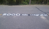
From the pond I scaled Bigelow and its multiple peaks. The views were amazing, but more than that it was on this mountain that I reached 2,000 miles. Two-thousand miles! I sat there on Avery Peak, the last 4,000-foot rise before Katahdin, and tried to take in the accomplishment. Despite how I might try, the magnitude of what those miles meant eluded me. So I hiked on, and was welcomed not only by a congratulatory sign painted on the road, but some cold, refreshing Cokes and Pabst Blue Ribbons stowed away in a cooler along the trail. Again, life was good, and getting better.
After downing two Cokes and taking some PBR poured into a Gatorade bottle for the trail (I didn't want to deal with the aluminum can later), I headed off to find a campsite for the day; given the good weather and desire to reflect, I wasn't interesting in staying at a shelter. Along the way I passed some of Maine's scenic ponds; I stopped for a rest at one that held a small sand beach nestled along its shore.
That resting spot made it clear that my goal for the day was to find a pond to camp by. It would mean a few extra miles, but I knew it would be worth it. I arrived at East Carry Pond at dusk, walking along its shore until I found a suitable spot on its north end. A small clearing in the trees gave me just enough room to lay out my sleeping bag on a flat, soft bed of pine needles -- I wasn't worried about needing my tent -- and a large rock jutting out into the water was the perfect spot to sit and relax as I made dinner.
As I ate, the beauty of my surroundings occupied my thoughts. I cracked open my repackaged PBR and listened to nearby coyotes howling back and forth as I watched the moon dip behind the pines. The evening seemed somehow magical, somehow just what I needed at the time. I curled up in my sleeping bag under the stars, well fed and content.
Dawn proved just as serene as the night before. I awoke to a pond that was covered in a morning mist. The surface of the water was so still that I could also see a near perfect relfection of the clouds on its mirrored surface. The only thing missing was someone to share the moment with.
 After sipping my morning coffee I scurried down the trail toward the Kennebec River. At nearly 70 yards wide, the river was massive. In addition, an upstream dam was known to raise the water level by as much as three feet without warning, generating a dangerous ford situation with unpredictable current. Well aware of the danger, the official AT route is to cross the Kennebec using the contracted ferry service. Of course, the term "ferry" is used loosely as it really is just the Ferry Man paddling a canoe. In fact, this is the last human-powered ferry service operating in the United States. To make sure that hikers didn't get overly worked up about the situation, there was a white blaze painted on the bottom of the canoe -- the most photographed white blaze of the entire trail.
From the Kennebec River I was only one day out from reaching Monson, ME. There I would meet my good friend Dave who would hike with me through the 100-mile Wilderness to the summit of Katahdin. As it turns out, the 100-mile was an adventure worth its own post, but for that story you'll just need to wait.


No comments:
Post a Comment